Darryl D’Monte, July 10, 2015
At a public meeting convened by the Mumbai Waterfronts Centre (MWC) on June 24, the Dutch Consul in Mumbai, Arend Gouw, said that the city’s ambitious, expensive Rs 11,300-crore coastal road, if not planned properly, would “homogenise” the coast.
He then corrected this to “destroy”.
On June 5, Dutch Prime Minister Mark Rutte attended a meeting with Maharashtra Chief Minister Devendra Fadnavis, where he announced Dutch technical assistance for the 34.6-km-long road—53 years after it was first planned—to be built at a cost of Rs 322 crore per km, or only Rs 28-crore per km less than Mumbai’s future Metro lines.
Holland has considerable experience in reclaiming land from the sea, but it does that to protect the coastal areas, vast tracts of which lie below the sea.
Rutte and other Dutch experts mentioned that in Holland, the government always considers the views of stakeholders before finalising a project. This saves both time and money.
The reverse has occurred with Mumbai’s coastal highway.
Make the plan, then call for comments
Dutch experts suggested incorporating the third Metro line, which traverses much of the route along the west coast, in the road. Fadnavis welcomed the proposal and is taking it further.
Mumbai Metro Rail officials present also pointed out that this Metro route was already finalised and in any case, a Metro along the sea wouldn’t be connected with existing rail and Metro lines inland.
Although the consultants presented the detailed project report (DPR) on the road on Mumbai’s western seafront this February, the municipal corporation only made it public on June 24.
This was after Union environment minister Prakash Javadekar cleared the road, connecting Nariman Point in south Mumbai to Kandiva li in the northern suburbs, on June 8, subject to two conditions:
One, to reclaim as little land for the project; such reclamation was halted in 1974 after protests by environmentalists.
Second, to retain the current building restrictions under the Coastal Regulation Zone (CRZ). These prohibit construction within 500 metres of the high-tide line.
Since the road will be constructed some 100-200 metres off the coast, there was the danger that the high-tide line would have been pushed back by that much, permitting construction on some of India’s most expensive real estate.
Activists attended a meeting convened by the MWC on July 3 to list their objections to the project, originally mooted by Los Angeles-based planners in 1962.
The DPR reveals the lack of institutional support for a coherent mobility policy, according to Rishi Aggarwal from the Observer Research Foundation.
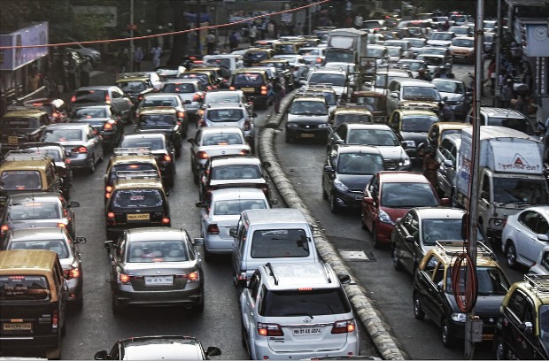
How car traffic to downtown Mumbai is drying up
A Unified Metropolitan Transport Authority (UMTA) was set up in 2008, but various agencies planned stand-alone projects without consulting each other.
In its current avatar, the coastal road was conceived by former Chief Minister Prithviraj Chouhan and was to be built originally by the state government. However, the BJP coalition in the state has handed it over to the municipal corporation, the long-time fiefdom of its political partner, the Shiv Sena.
The authorities should have identified earlier road projects, including tunnels, which have not been executed, before taking on a project that will change the face of the city, Aggarwal said.
What is the coastal road for, asked Hussain Indorewalla, a professor of the Kamala Raheja College of Architecture. While Javadekar said that the coastal road is meant to decongest the city, Indorewalla believed it would be counter-productive.
When Nitin Gadkari was the PWD minister in the BJP-Sena coalition in the state in the early 1990s, he built 55 flyovers in Mumbai. While these eased traffic temporarily, the number of cars increased, creating traffic snarls.
The DPR itself cites how due to the global economic downturn, the population growth of Mumbai has slowed perceptibly. Between 2001 and 2011, the city only grew by 500,000 people.
It shows that the growth in car traffic will peak at 3% per annum between 2015 and 2019, slowing down to 0.3% between 2040 and 2043, an average of only 1.7% in these 28 years.
It estimated a maximum of 34,090 cars per day in 2014 through the existing Bandra-Worli Sea Link (BWSL), which was built in 2009 and will be connected to the road. This dropped to 11,378 cars at its southernmost section at Nariman Point.
In 2044, it estimated at most 61,749 cars a day at BWSL, dropping to 27,616 at Nariman Point.
Nariman Point and south Mumbai are losing their clout as the old central business district. They are ceding ground to the Bandra-Kurla Complex, where real estate prices are higher. Other centres have opened up in the suburbs too for IT and other industries.
Be the first to comment